
Amareleja topographic map
Interactive map
Click on the map to display elevation.
About this map
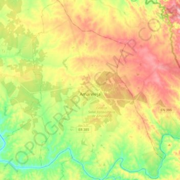
Name: Amareleja topographic map, elevation, terrain.
Location: Amareleja, Moura, Beja, Portugal (38.13805 -7.29335 38.28182 -7.15203)
Average elevation: 198 m
Minimum elevation: 101 m
Maximum elevation: 305 m
Other topographic maps
Click on a map to view its topography, its elevation and its terrain.
Região do Alentejo
Região do Alentejo, Beja, 7800-246, Portugal
Average elevation: 170 m
Castro Verde
Portugal > Beja > Castro Verde e Casével > Castro Verde
Castro Verde, Castro Verde e Casével, Castro Verde, Beja, Alentejo, 7780-173, Portugal
Average elevation: 212 m