
Colachel topographic map
Interactive map
Click on the map to display elevation.
Colachel
The town is located on the western coastal side of Kanyakumari District and falls in the coordinates of 8°09′N 77°08′E / 8.15°N 77.14°E / 8.15; 77.14. The average elevation of the town is 25 meters (82 ft) above Mean Sea Level (MSL). Town is mostly characterized by a flat terrain with a few areas in the northwest region having elevation difference with other parts of the town. Generally the town is sloped gently from North to south direction and also sloping in a radial direction towards centre portion of the town from east and west directions.
About this map
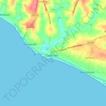
Name: Colachel topographic map, elevation, terrain.
Location: Colachel, Kalkulam, Kanniyakumari, Tamil Nadu, 629251, India (8.13527 77.21192 8.21527 77.29192)
Average elevation: 16 m
Minimum elevation: -1 m
Maximum elevation: 72 m
Other topographic maps
Click on a map to view its topography, its elevation and its terrain.