
Groß Vollstedt topographic map
Interactive map
Click on the map to display elevation.
About this map
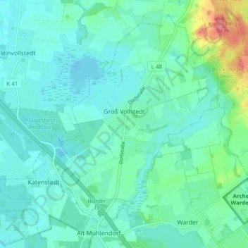
Name: Groß Vollstedt topographic map, elevation, terrain.
Average elevation: 26 m
Minimum elevation: 12 m
Maximum elevation: 85 m
Other topographic maps
Click on a map to view its topography, its elevation and its terrain.
Brekendorf
Deutschland > Schleswig-Holstein > Rendsburg-Eckernförde
Brekendorf, Hüttener Berge, Rendsburg-Eckernförde, Schleswig-Holstein, Deutschland
Average elevation: 33 m
Rendsburg
Deutschland > Schleswig-Holstein > Rendsburg-Eckernförde
Rendsburg, Rendsburg-Eckernförde, Schleswig-Holstein, 24768, Deutschland
Average elevation: 9 m