
泽库县 topographic map
Interactive map
Click on the map to display elevation.
About this map
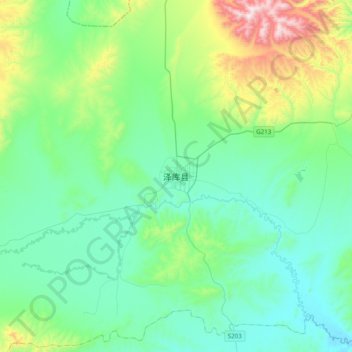
Name: 泽库县 topographic map, elevation, terrain.
Location: 泽库县, 黄南藏族自治州, 青海省, 中国 (34.87619 101.30825 35.19619 101.62825)
Average elevation: 3,759 m
Minimum elevation: 3,572 m
Maximum elevation: 4,486 m
Other topographic maps
Click on a map to view its topography, its elevation and its terrain.