
Lamont topographic map
Interactive map
Click on the map to display elevation.
About this map
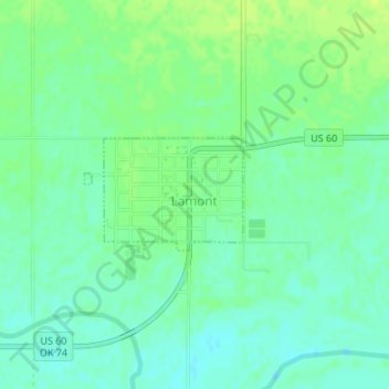
Name: Lamont topographic map, elevation, terrain.
Location: Lamont, Grant County, Oklahoma, 74643, United States (36.68714 -97.56597 36.69496 -97.55216)
Average elevation: 308 m
Minimum elevation: 300 m
Maximum elevation: 316 m
Other topographic maps
Click on a map to view its topography, its elevation and its terrain.
Nash
United States > Oklahoma > Grant County
Nash, Grant County, Oklahoma, 73761, United States
Average elevation: 344 m
Pond Creek
United States > Oklahoma > Grant County
Pond Creek, Grant County, Oklahoma, 73766, United States
Average elevation: 321 m
Renfrow
United States > Oklahoma > Grant County
Renfrow, Grant County, Oklahoma, United States
Average elevation: 369 m
Wakita
United States > Oklahoma > Grant County
Wakita, Grant County, Oklahoma, 73771, United States
Average elevation: 356 m
Manchester
United States > Oklahoma > Grant County
Manchester, Grant County, Oklahoma, United States
Average elevation: 390 m
Deer Creek
United States > Oklahoma > Grant County
Deer Creek, Grant County, Oklahoma, 74636, United States
Average elevation: 329 m
Medford
United States > Oklahoma > Grant County
Medford, Grant County, Oklahoma, 73759, United States
Average elevation: 331 m