Geolocate

Hesa Awal Kohistan topographic map

Interactive map

Click on the map to display elevation.

About this map

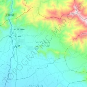
Name: Hesa Awal Kohistan topographic map, elevation, terrain.

Location: Hesa Awal Kohistan, Kapisa Province, Afghanistan (35.08118 69.28195 35.18496 69.43305)

Average elevation: 1,895 m

Minimum elevation: 1,498 m

Maximum elevation: 3,282 m

Other topographic maps

Click on a map to view its topography, its elevation and its terrain.

Tagab

Afghanistan > Kapisa Province

Tagab, Kapisa Province, Afghanistan

Average elevation: 1,767 m

Mahmud Raqi

Afghanistan > Kapisa Province

Mahmud Raqi, Kapisa Province, Afghanistan

Average elevation: 1,598 m

Nijrab

Afghanistan > Kapisa Province

Nijrab, Kapisa Province, Afghanistan

Average elevation: 2,690 m

Alah Say

Afghanistan > Kapisa Province

Alah Say, Alasay District, Kapisa Province, Afghanistan

Average elevation: 2,420 m

Kohband

Afghanistan > Kapisa Province

Kohband, Kapisa Province, Afghanistan

Average elevation: 2,439 m