
Jatimulya topographic map
Interactive map
Click on the map to display elevation.
About this map
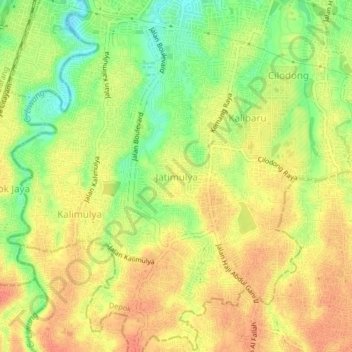
Name: Jatimulya topographic map, elevation, terrain.
Location: Jatimulya, Depok, West Java, Java, 16413, Indonesia (-6.46668 106.81357 -6.42668 106.85357)
Average elevation: 111 m
Minimum elevation: 77 m
Maximum elevation: 130 m
Other topographic maps
Click on a map to view its topography, its elevation and its terrain.