
Make a donation
Gear up for your next adventure:
As an Amazon Associate, this site earns from qualifying purchases at no extra cost to you.
Reddingmuirhead topographic map
Click on the map to display elevation.
Make a donation
Gear up for your next adventure:
As an Amazon Associate, this site earns from qualifying purchases at no extra cost to you.
About this map
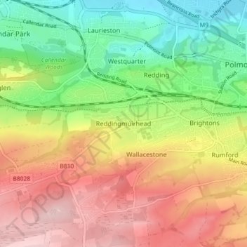
Name: Reddingmuirhead topographic map, elevation, terrain.
Location: Reddingmuirhead, Falkirk, Scotland, FK2 0GS, United Kingdom (55.96106 -3.76129 56.00106 -3.72129)
Average elevation: 102 m
Minimum elevation: 4 m
Maximum elevation: 206 m
Falkirk trails, hiking, mountain biking, running and outdoor activities
Make a donation
Gear up for your next adventure:
As an Amazon Associate, this site earns from qualifying purchases at no extra cost to you.
Other topographic maps
Click on a map to view its topography, its elevation and its terrain.
Falkirk
United Kingdom > Scotland > Falkirk
Falkirk is located in an area of undulating topography between the Slamannan Plateau and the upper reaches of the Firth of Forth. The area to the north of Falkirk is part of the floodplain of the River Carron. Two tributaries of the River Carron - the East Burn and the West Burn flow through the town and form…
Average elevation: 42 m
Make a donation
Gear up for your next adventure:
As an Amazon Associate, this site earns from qualifying purchases at no extra cost to you.
Make a donation
Gear up for your next adventure:
As an Amazon Associate, this site earns from qualifying purchases at no extra cost to you.
Union Canal
United Kingdom > Scotland > Falkirk
Canal commences from the sixteenth lock of the Forth and Clyde Navigation, about two miles west of Falkirk, in the county of Sterling , whence it takes an eastwardly course on the south side of the above-mentioned town, by some collieries; thence, through Black Hill Tunnel, and across the Glen Water, on which…
Average elevation: 136 m
Falkirk
United Kingdom > Scotland > Falkirk
Falkirk is located in an area of undulating topography between the Slamannan Plateau and the upper reaches of the Firth of Forth. The area to the north of Falkirk is part of the floodplain of the River Carron. Two tributaries of the River Carron - the East Burn and the West Burn flow through the town and form…
Average elevation: 42 m