
Make a donation
Gear up for your next adventure:
As an Amazon Associate, this site earns from qualifying purchases at no extra cost to you.
Iskushuban topographic map
Click on the map to display elevation.
Make a donation
Gear up for your next adventure:
As an Amazon Associate, this site earns from qualifying purchases at no extra cost to you.
About this map
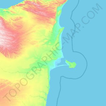
Name: Iskushuban topographic map, elevation, terrain.
Location: Iskushuban, Bari, Puntland, Somalia (9.81000 49.56000 11.50115 51.61777)
Average elevation: 240 m
Minimum elevation: -3 m
Maximum elevation: 1,606 m
Make a donation
Gear up for your next adventure:
As an Amazon Associate, this site earns from qualifying purchases at no extra cost to you.
Other topographic maps
Click on a map to view its topography, its elevation and its terrain.
Make a donation
Gear up for your next adventure:
As an Amazon Associate, this site earns from qualifying purchases at no extra cost to you.
Somali Peninsula
Somalia > Bari > Qardho District
In Somalia, there is not much seasonal variation in climate. Hot conditions prevail year-round along with periodic monsoon winds and irregular rainfall. Mean daily maximum temperatures range from 28 to 43 °C (82 to 109 °F), except at higher elevations along the eastern seaboard, where the effects of a cold…
Average elevation: 840 m
Make a donation
Gear up for your next adventure:
As an Amazon Associate, this site earns from qualifying purchases at no extra cost to you.
Make a donation
Gear up for your next adventure:
As an Amazon Associate, this site earns from qualifying purchases at no extra cost to you.
Bari
Somalia > Bari > Iskushuban
In terms of landmass, Bari is the largest province in the Federal Republic of Somalia. The highest point in this region is Mount Bahaya, the third tallest mountain in Somalia with an elevation of 2120 meters; other notable peaks include Karkaar and Cal Miskaad mountains.
Average elevation: 503 m