
Thank you for supporting this site ❤️
Make a donation
Make a donation
Gear up for your next adventure:
As an Amazon Associate, this site earns from qualifying purchases at no extra cost to you.
Vella topographic map
Click on the map to display elevation.
Thank you for supporting this site ❤️
Make a donation
Make a donation
Gear up for your next adventure:
As an Amazon Associate, this site earns from qualifying purchases at no extra cost to you.
About this map
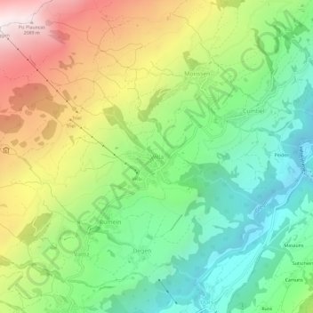
Name: Vella topographic map, elevation, terrain.
Location: Vella, Lumnezia, Surselva, Grisons, 7143, Switzerland (46.69928 9.15313 46.73928 9.19313)
Average elevation: 1,318 m
Minimum elevation: 814 m
Maximum elevation: 2,102 m
Thank you for supporting this site ❤️
Make a donation
Make a donation
Gear up for your next adventure:
As an Amazon Associate, this site earns from qualifying purchases at no extra cost to you.