
Syresham topographic map
Click on the map to display elevation.
About this map
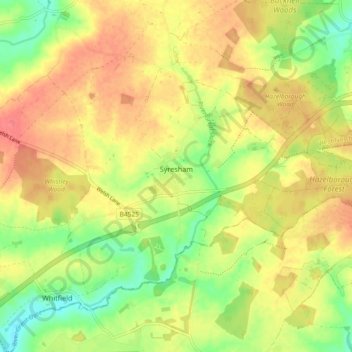
Name: Syresham topographic map, elevation, terrain.
Location: Syresham, West Northamptonshire, England, United Kingdom (52.05119 -1.11730 52.08765 -1.02516)
Average elevation: 138 m
Minimum elevation: 107 m
Maximum elevation: 163 m
West Northamptonshire trails, hiking, mountain biking, running and outdoor activities
Other topographic maps
Click on a map to view its topography, its elevation and its terrain.
Lower Thorpe
United Kingdom > England > West Northamptonshire > Thorpe Mandeville
Average elevation: 154 m
Ravensthorpe Reservoir
United Kingdom > England > West Northamptonshire > Coton
Average elevation: 131 m