
Make a donation
Gear up for your next adventure:
As an Amazon Associate, this site earns from qualifying purchases at no extra cost to you.
Laval topographic map
Click on the map to display elevation.
Make a donation
Gear up for your next adventure:
As an Amazon Associate, this site earns from qualifying purchases at no extra cost to you.
Laval
Elevation varies between 42 and 122 meters above sea level. Laval is, in fact, a hilly town, marked by a rocky promontory dominating the valley of the Mayenne river. The castle was built on this promontory and the medieval centre spreads around. The promontory and the slightly hilly landscape around Laval are traces of the Armorican Massif, an old range of mountains that forms the Breton peninsula.
Make a donation
Gear up for your next adventure:
As an Amazon Associate, this site earns from qualifying purchases at no extra cost to you.
About this map
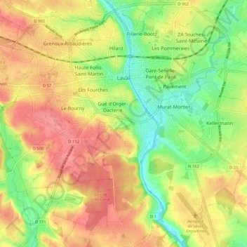
Name: Laval topographic map, elevation, terrain.
Average elevation: 87 m
Minimum elevation: 42 m
Maximum elevation: 128 m
Make a donation
Gear up for your next adventure:
As an Amazon Associate, this site earns from qualifying purchases at no extra cost to you.
Other topographic maps
Click on a map to view its topography, its elevation and its terrain.
Make a donation
Gear up for your next adventure:
As an Amazon Associate, this site earns from qualifying purchases at no extra cost to you.
Make a donation
Gear up for your next adventure:
As an Amazon Associate, this site earns from qualifying purchases at no extra cost to you.
Mont des Avaloirs
France > Pays de la Loire > Mayenne > Pré-en-Pail-Saint-Samson
Average elevation: 356 m