
Schloss Scharnhausen topographic map
Interactive map
Click on the map to display elevation.
About this map
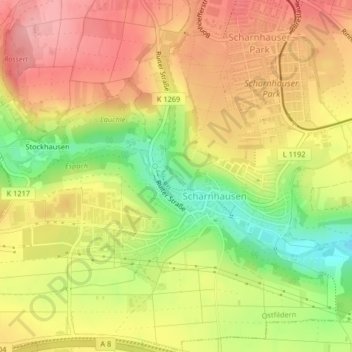
Name: Schloss Scharnhausen topographic map, elevation, terrain.
Average elevation: 357 m
Minimum elevation: 290 m
Maximum elevation: 405 m
Other topographic maps
Click on a map to view its topography, its elevation and its terrain.
Körsch
Deutschland > Baden-Württemberg > Landkreis Esslingen > Scharnhausen
Körsch, Scharnhausen, Ostfildern, Landkreis Esslingen, Baden-Württemberg, 73760, Deutschland
Average elevation: 363 m