Geolocate

Al Salt topographic map

Click on the map to display elevation.

About this map

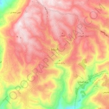
Name: Al Salt topographic map, elevation, terrain.

Location: Al Salt, Al-Salt Sub-District, Salt Qasabah District, Balqa, Jordan (31.99795 35.68299 32.07260 35.76413)

Average elevation: 854 m

Minimum elevation: 436 m

Maximum elevation: 1,096 m

Other topographic maps

Click on a map to view its topography, its elevation and its terrain.

Khirbat al Innab

Jordan > Balqa > Al-Salt Sub-District

Average elevation: 744 m

البقورية

Jordan > Balqa > Al-Salt Sub-District

Average elevation: 540 m

البطين

Jordan > Balqa > Al-Salt Sub-District

Average elevation: 655 m

Wadi Shuʿeib

Jordan > Balqa > Al-Salt Sub-District > Al Salt

Wadi Shueib lies west of Sweileh at elevations from 1,200 meters (3,900 ft) to sea level. It drains an area of approximately 180 square kilometers (69 sq mi).

Average elevation: 857 m

Gear up for your next adventure:

📱Phone Mounts for Hiking - Secure mounts to carry your phone on trails
📢Survival Whistles - Essential safety gear for signaling for help in mountain fog
🕶️Glacier Goggles - Maximum protection for high-altitude snow topography
🥫Expedition Meals - Lightweight, high-calorie nutrition for long-distance hikers
🧗Locking Carabiners - Secure gear to your pack or for light technical use

As an Amazon Associate, this site earns from qualifying purchases at no extra cost to you.