
Sterkfontein Dam Nature Reserve topographic map
Interactive map
Click on the map to display elevation.
About this map
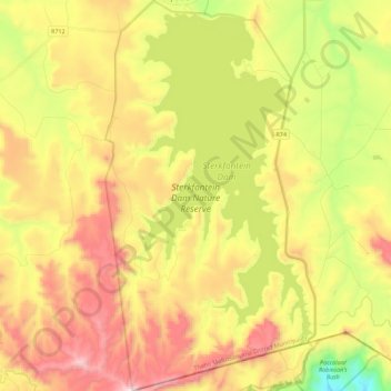
Name: Sterkfontein Dam Nature Reserve topographic map, elevation, terrain.
Average elevation: 1,766 m
Minimum elevation: 1,272 m
Maximum elevation: 2,282 m
Other topographic maps
Click on a map to view its topography, its elevation and its terrain.
Maluti-a-Phofung Ward 27
RSA > Free State > Maluti-a-Phofung Local Municipality
Maluti-a-Phofung Ward 27, Maluti-a-Phofung Local Municipality, Thabo Mofutsanyana District Municipality, Free State, RSA
Average elevation: 1,670 m
Maluti-a-Phofung Ward 20
RSA > Free State > Maluti-a-Phofung Local Municipality
Maluti-a-Phofung Ward 20, Maluti-a-Phofung Local Municipality, Thabo Mofutsanyana District Municipality, Free State, RSA
Average elevation: 2,228 m