
Montcal topographic map
Interactive map
Click on the map to display elevation.
About this map
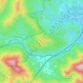
Name: Montcal topographic map, elevation, terrain.
Average elevation: 115 m
Minimum elevation: 9 m
Maximum elevation: 334 m
Other topographic maps
Click on a map to view its topography, its elevation and its terrain.
Madres
Espagne > Catalogne > Haut-Ampurdan > Llançà
Madres, Llançà, Haut-Ampurdan, Gérone, Catalogne, 17490, Espagne
Average elevation: 112 m