Geolocate

Pulpally topographic map

Click on the map to display elevation.

About this map
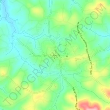
Name: Pulpally topographic map, elevation, terrain.

Location: Pulpally, Sulthanbathery, Wayanad, Kerala, 673579, India (11.77327 76.14439 11.81327 76.18439)

Average elevation: 781 m

Minimum elevation: 733 m

Maximum elevation: 877 m

Other topographic maps

Click on a map to view its topography, its elevation and its terrain.
Kuruva Island

India > Kerala > Sulthanbathery

Average elevation: 733 m

Kenichira

India > Kerala > Sulthanbathery

Average elevation: 788 m

Sulthan Bathery

India > Kerala > Sulthanbathery > Sultan Bathery

Average elevation: 873 m

Marakavu

India > Kerala > Sulthanbathery > Pulpally

Average elevation: 769 m

Nellarachal

India > Kerala > Sulthanbathery

Average elevation: 781 m

Vadakkanad

India > Kerala > Sulthanbathery

Average elevation: 896 m

Edakkal

India > Kerala > Sulthanbathery > Ambalavayal

Average elevation: 927 m

Kalluvayal

India > Kerala > Sulthanbathery > Pulpally

Average elevation: 816 m

Seethamount

India > Kerala > Sulthanbathery > Kabanigiri

Average elevation: 731 m

Kalluvayal

India > Kerala > Sulthanbathery > Pulpally

Average elevation: 816 m

Poothadi

India > Kerala > Sulthanbathery

Average elevation: 742 m

Sulthan Bathery

India > Kerala > Sulthanbathery > Sultan Bathery

Average elevation: 873 m

Gear up for your next adventure:

🧷Tenacious Repair Tape - Instant fix for torn tents, jackets, or dry bags
🎒Hiking Daypacks - Compact backpacks ideal for short hikes and excursions
📷Outdoor Action Cameras - Cameras designed for hiking and adventure
📕Outdoor Navigation Books - Learn traditional and modern navigation techniques
🧊Personal Water Filters - Drink safely from mountain streams marked on your map

As an Amazon Associate, this site earns from qualifying purchases at no extra cost to you.