
Thank you for supporting this site ❤️
Make a donation
Make a donation
Gear up for your next adventure:
As an Amazon Associate, this site earns from qualifying purchases at no extra cost to you.
Puerto Plata topographic map
Click on the map to display elevation.
Thank you for supporting this site ❤️
Make a donation
Make a donation
Gear up for your next adventure:
As an Amazon Associate, this site earns from qualifying purchases at no extra cost to you.
Puerto Plata
Su topografía es escalonada, presentando la ciudad una vista casi completa desde el puerto.
Thank you for supporting this site ❤️
Make a donation
Make a donation
Gear up for your next adventure:
As an Amazon Associate, this site earns from qualifying purchases at no extra cost to you.
About this map
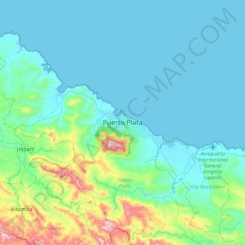
Name: Puerto Plata topographic map, elevation, terrain.
Location: Puerto Plata, República Dominicana (19.62940 -70.85405 19.94940 -70.53405)
Average elevation: 119 m
Minimum elevation: 0 m
Maximum elevation: 775 m
Thank you for supporting this site ❤️
Make a donation
Make a donation
Gear up for your next adventure:
As an Amazon Associate, this site earns from qualifying purchases at no extra cost to you.