Geolocate

Telepayong topographic map

Click on the map to display elevation.

About this map

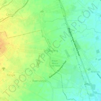
Name: Telepayong topographic map, elevation, terrain.

Location: Telepayong, Arayat, Pampanga, Central Luzon, Philippines (15.15723 120.64784 15.19723 120.68784)

Average elevation: 42 m

Minimum elevation: 28 m

Maximum elevation: 56 m

Gear up for your next adventure:

🔪Outdoor Multi-Tools - Versatile tools for gear repairs and food prep in the wild
🎒Multi-day Trekking Packs - Large capacity backpacks for wild camping and long-distance trails
🛰️Satellite Messengers - Emergency communication devices for areas without mobile signal
🖼️Topographic Map Art - Decorative 3D-effect posters of famous UK peaks and regions
📱Phone Mounts for Hiking - Secure mounts to carry your phone on trails

As an Amazon Associate, this site earns from qualifying purchases at no extra cost to you.