
Make a donation
Gear up for your next adventure:
As an Amazon Associate, this site earns from qualifying purchases at no extra cost to you.
Pueblo Rico topographic map
Click on the map to display elevation.
Make a donation
Gear up for your next adventure:
As an Amazon Associate, this site earns from qualifying purchases at no extra cost to you.
Pueblo Rico
90 km. separan a Pueblo Rico de Pereira, con una carretera llena de inigualables paisajes que muestran la gran topografía con que cuenta Colombia haciendo el viaje agradable a la vista.
Make a donation
Gear up for your next adventure:
As an Amazon Associate, this site earns from qualifying purchases at no extra cost to you.
About this map
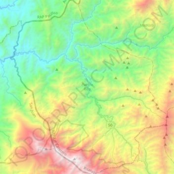
Name: Pueblo Rico topographic map, elevation, terrain.
Average elevation: 1,611 m
Minimum elevation: 307 m
Maximum elevation: 4,083 m
Make a donation
Gear up for your next adventure:
As an Amazon Associate, this site earns from qualifying purchases at no extra cost to you.
Other topographic maps
Click on a map to view its topography, its elevation and its terrain.
Peña Bonita
Colombia > Risaralda > AMCO, Area Metropolitana Centro Occidente
Average elevation: 2,977 m