
Make a donation
Gear up for your next adventure:
As an Amazon Associate, this site earns from qualifying purchases at no extra cost to you.
Isle Royale topographic map
Click on the map to display elevation.
Make a donation
Gear up for your next adventure:
As an Amazon Associate, this site earns from qualifying purchases at no extra cost to you.
Isle Royale
The island offers approximately 170 miles (270 km) of hiking trails for everything from day hikes to a two-week circumnavigation hike. Some of the hiking trails are quite challenging, with steep grades. "The most popular, best marked and longest single route ...is the 40-mile Greenstone Ridge Trail that extends down the island's backbone." The trail leads to the peak of Mount Desor, at 1,394 feet (425 m), the highest point on the island, and passes through northwoods wilderness, and by inland glacial lakes, swamps, bogs and scenic shorelines. The most difficult trail is the Minong Ridge, which has a 13-mile hike from North Lake Desor to Windigo. It passes through quick elevation changes, high plants, and miles upon miles of hiking on ridges overlooking Lake Superior.
Make a donation
Gear up for your next adventure:
As an Amazon Associate, this site earns from qualifying purchases at no extra cost to you.
About this map
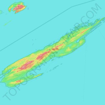
Name: Isle Royale topographic map, elevation, terrain.
Location: Isle Royale, Keweenaw County, Michigan, United States (47.82376 -89.23555 48.19102 -88.42232)
Average elevation: 190 m
Minimum elevation: 176 m
Maximum elevation: 443 m
Make a donation
Gear up for your next adventure:
As an Amazon Associate, this site earns from qualifying purchases at no extra cost to you.