
Make a donation
Gear up for your next adventure:
As an Amazon Associate, this site earns from qualifying purchases at no extra cost to you.
Sofia topographic map
Click on the map to display elevation.
Make a donation
Gear up for your next adventure:
As an Amazon Associate, this site earns from qualifying purchases at no extra cost to you.
Sofia
Sofia City Province has an area of 1344 km2, while the surrounding and much bigger Sofia Province is 7,059 km2. Sofia's development as a significant settlement owes much to its central position in the Balkans. It is situated in western Bulgaria, at the northern foot of the Vitosha mountain, in the Sofia Valley that is surrounded by the Balkan mountains to the north. The valley has an average altitude of 550 metres (1,800 ft). Sofia is the second highest capital of the European Union (after Madrid) and the third highest capital of Europe (after Andorra la Vella and Madrid). Unlike most European capitals, Sofia does not straddle any large river, but is surrounded by comparatively high mountains on all sides. Three mountain passes lead to the city, which have been key roads since antiquity, Vitosha being the watershed between Black and Aegean Seas.
Make a donation
Gear up for your next adventure:
As an Amazon Associate, this site earns from qualifying purchases at no extra cost to you.
About this map
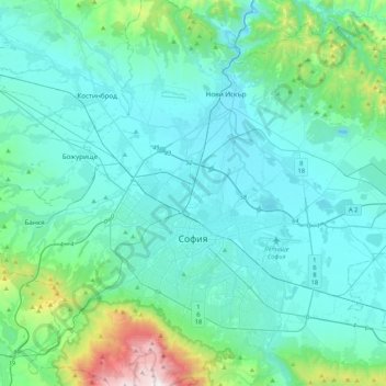
Name: Sofia topographic map, elevation, terrain.
Location: Sofia, Sredec, Sofia City, Sofia-City, Bulgaria (42.55799 23.16800 42.86430 23.62158)
Average elevation: 746 m
Minimum elevation: 500 m
Maximum elevation: 2,279 m
Make a donation
Gear up for your next adventure:
As an Amazon Associate, this site earns from qualifying purchases at no extra cost to you.