
Addis Ababa topographic map
Click on the map to display elevation.
Addis Ababa
Moreover, the city held strong social organizations pattern prior Italian invasion. According to Richard Pankhurst (1968), the city accelerated population growth due to factors of provisional governors and their troops, the 1892 famine, eventually the Battle of Adwa. Another include the 1907 land act, municipal administration in 1909, and railway and modernized transportation system boom beginning in the 20th century, culminating in continual growth. Additional supplements, for example the laid of Ethio-Djibouti Railways and topographical factors more led the city's boundary to expand southward.
About this map
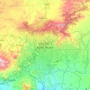
Name: Addis Ababa topographic map, elevation, terrain.
Location: Addis Ababa, Arada, Addis Ababa, 3578, Ethiopia (8.87583 38.59241 9.19583 38.91241)
Average elevation: 2,517 m
Minimum elevation: 2,058 m
Maximum elevation: 3,383 m
Other topographic maps
Click on a map to view its topography, its elevation and its terrain.