
New York topographic map
Interactive map
Click on the map to display elevation.
New York
New York City's topography is a fascinating blend of varied elevations and unique landscapes, reflecting its diverse geography across five boroughs. Situated at the confluence of the Hudson and East Rivers, the city primarily features low-lying terrain, with the average elevation hovering around sea level. However, notable hills punctuate the urban landscape, especially in the Bronx, which has rolling hills in areas like Riverdale, and Staten Island, where Todt Hill rises to approximately 410 feet (125 meters), making it the highest point in the city. Manhattan showcases its highest natural point at Bennett Park, reaching about 265 feet (81 meters), while areas like Central Park offer elevated spots, providing scenic views amidst the urban setting. Queens presents a mix of coastal lowlands and higher elevations, particularly in neighborhoods like Forest Hills, while Brooklyn's varied terrain ranges from flatlands at Coney Island to elevated areas such as Park Slope. Overall, the city's topography significantly influences its infrastructure, recreational spaces, and urban planning.
About this map
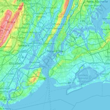
Name: New York topographic map, elevation, terrain.
Location: New York, United States (40.47658 -74.25884 40.91763 -73.70023)
Average elevation: 19 m
Minimum elevation: -6 m
Maximum elevation: 207 m
Other topographic maps
Click on a map to view its topography, its elevation and its terrain.
Central Park
United States > New York > New York County > New York
In June 1856, Fernando Wood appointed a "consulting board" of seven people, headed by author Washington Irving, to inspire public confidence in the proposed development. Wood hired military engineer Egbert Ludovicus Viele as the park's chief engineer, tasking him with a topographical survey of the site. The…
Average elevation: 26 m
Whitehall Corners
United States > New York > Westchester County > Town of Somers
Average elevation: 97 m
Central Park
United States > New York > New York County > New York
In June 1856, Fernando Wood appointed a "consulting board" of seven people, headed by author Washington Irving, to inspire public confidence in the proposed development. Wood hired military engineer Egbert Ludovicus Viele as the park's chief engineer, tasking him with a topographical survey of the site. The…
Average elevation: 26 m
Lake Tonetta
United States > New York > Putnam County > Brewster > Brewster Hill
Average elevation: 155 m
Eastport South Manor Athletic Complex
United States > New York > Suffolk County > Town of Brookhaven > Eastport
Average elevation: 15 m
Sunset Ridge
United States > New York > Westchester County > Town/Village of Harrison
Average elevation: 27 m
Lee Town Park
United States > New York > Oneida County > Lake Delta > Town of Lee
Average elevation: 184 m
Heath Ridge
United States > New York > Westchester County > Village of Scarsdale
Average elevation: 66 m
Tug Hill
United States > New York > Oswego County
The core Tug Hill region encompasses 150,000 acres (610 km2) of unbroken, generally second-growth, northern hardwood forest, and is drained by a vast network of streams. Important rivers and streams whose headwaters are located within the Tug Hill region include the Mohawk River, Deer River, Salmon River, Mad…
Average elevation: 109 m
Barnum Corners
United States > New York > Putnam County > Town of Patterson > Putnam Lake
Average elevation: 174 m
Preston Hollow
United States > New York > Albany County > Town of Rensselaerville
Average elevation: 372 m
Tompkins Corners
United States > New York > Putnam County > Town of Putnam Valley
Average elevation: 208 m
Central Park
United States > New York > New York County > New York
In June 1856, Fernando Wood appointed a "consulting board" of seven people, headed by author Washington Irving, to inspire public confidence in the proposed development. Wood hired military engineer Egbert Ludovicus Viele as the park's chief engineer, tasking him with a topographical survey of the site. The…
Average elevation: 26 m
Niagara Escarpment
United States > New York > Niagara County > City of Lockport
Average elevation: 149 m