Geolocate

English topographic map

Click on the map to display elevation.

About this map

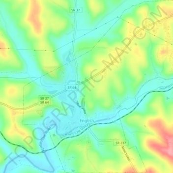
Name: English topographic map, elevation, terrain.

Location: English, Crawford County, Indiana, United States (38.32375 -86.48087 38.35912 -86.43989)

Average elevation: 184 m

Minimum elevation: 148 m

Maximum elevation: 248 m

Other topographic maps

Click on a map to view its topography, its elevation and its terrain.

Magnolia

United States > Indiana > Crawford County

Average elevation: 197 m

Taswell

United States > Indiana > Crawford County

Average elevation: 218 m

Gear up for your next adventure:

🔪Outdoor Multi-Tools - Versatile tools for gear repairs and food prep in the wild
🦶Anti-Blister Balms - Protect your feet before long topographic expeditions
Insulated Travel Mugs - Keep drinks hot while surveying the landscape from a summit
🧦Hiking Socks - Breathable socks designed to prevent blisters on long walks
🧥Packable Down Jackets - Lightweight warmth that compresses small in your bag

As an Amazon Associate, this site earns from qualifying purchases at no extra cost to you.