Geolocate

Taswell topographic map

Click on the map to display elevation.

About this map

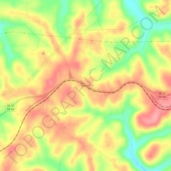
Name: Taswell topographic map, elevation, terrain.

Location: Taswell, Crawford County, Indiana, 47175, United States (38.31423 -86.58110 38.35423 -86.54110)

Average elevation: 218 m

Minimum elevation: 162 m

Maximum elevation: 258 m

Other topographic maps

Click on a map to view its topography, its elevation and its terrain.

Leavenworth

United States > Indiana > Crawford County

Average elevation: 159 m

English

United States > Indiana > Crawford County

Average elevation: 184 m

English

United States > Indiana > Crawford County

Average elevation: 184 m

English

United States > Indiana > Crawford County

Average elevation: 184 m

English

United States > Indiana > Crawford County

Average elevation: 184 m

Marengo

United States > Indiana > Crawford County

Average elevation: 206 m

Marengo

United States > Indiana > Crawford County

Average elevation: 206 m

Gear up for your next adventure:

🧭GPS Trackers - Tracking devices for safety and navigation
🦟Anti-Midge & Tick Repellent - Vital for hiking in the Scottish Highlands during summer
🦯Walking Poles - Supportive poles for long-distance walking
📷Outdoor Action Cameras - Cameras designed for hiking and adventure
🧥Waterproof Hiking Jackets - Rain protection for walking in all weather conditions

As an Amazon Associate, this site earns from qualifying purchases at no extra cost to you.