Geolocate

Oso topographic map

Click on the map to display elevation.

About this map

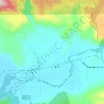
Name: Oso topographic map, elevation, terrain.

Location: Oso, Snohomish County, Washington, United States (48.25854 -121.94224 48.29767 -121.88147)

Average elevation: 127 m

Minimum elevation: 46 m

Maximum elevation: 444 m

Gear up for your next adventure:

🎒Replacement Sternum Straps - Repair parts for hiking rucksacks
🧺Ultralight Dry Bags - Organize and waterproof your gear inside your rucksack
Lightweight Tents - Compact tents for backpacking and trekking
🧺Microfibre Travel Towels - Fast-drying and compact towels for wild swimming and camping
🥾Hiking Boots - Waterproof and durable boots for long-distance hiking in the UK

As an Amazon Associate, this site earns from qualifying purchases at no extra cost to you.