Geolocate

Sonsbeek topographic map

Click on the map to display elevation.

About this map

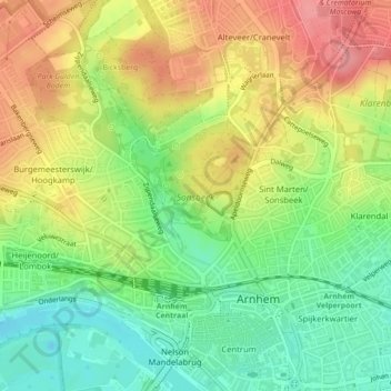
Name: Sonsbeek topographic map, elevation, terrain.

Location: Sonsbeek, Arnhem, Gelderland, Netherlands (51.98608 5.89660 51.99674 5.91033)

Average elevation: 43 m

Minimum elevation: -1 m

Maximum elevation: 90 m

Other topographic maps

Click on a map to view its topography, its elevation and its terrain.

Arnhem

Netherlands > Gelderland > Arnhem

Average elevation: 24 m

Elden

Netherlands > Gelderland > Arnhem

Average elevation: 11 m

Gear up for your next adventure:

🌄Outdoor Binoculars - Compact binoculars for landscape observation
🧭Professional Hiking Compasses - High-precision liquid-filled compasses for map reading and orientation
🪢Paracord - Multi-purpose cord for camping and survival
🧤Thermal Touchscreen Gloves - Stay warm while operating your GPS or smartphone camera
🔥Emergency Fire Starters - Reliable ignition tools for survival situations in damp conditions

As an Amazon Associate, this site earns from qualifying purchases at no extra cost to you.