Geolocate

Bukit Besar topographic map

Click on the map to display elevation.

About this map

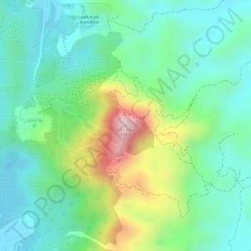
Name: Bukit Besar topographic map, elevation, terrain.

Location: Bukit Besar, Kulim, Kedah, Malaysia (5.33352 100.56255 5.33362 100.56265)

Average elevation: 140 m

Minimum elevation: 29 m

Maximum elevation: 380 m

Other topographic maps

Click on a map to view its topography, its elevation and its terrain.

Taman Tasik Putra

Malaysia > Kedah > Kulim

Average elevation: 40 m

Sungai Ular

Malaysia > Kedah > Kulim > Kampung Paya Tok Betok

Average elevation: 43 m

Gear up for your next adventure:

🥾Hiking Boots - Waterproof and durable boots for long-distance hiking in the UK
🧊Personal Water Filters - Drink safely from mountain streams marked on your map
🧥Waterproof Hiking Jackets - Rain protection for walking in all weather conditions
🧊Insulated Flasks - Keeps drinks hot or cold during hikes
🧣Fleece Neck Warmers - Extra insulation for winter topographic surveys

As an Amazon Associate, this site earns from qualifying purchases at no extra cost to you.