
Make a donation
Gear up for your next adventure:
As an Amazon Associate, this site earns from qualifying purchases at no extra cost to you.
Augusta topographic map
Click on the map to display elevation.
Make a donation
Gear up for your next adventure:
As an Amazon Associate, this site earns from qualifying purchases at no extra cost to you.
About this map
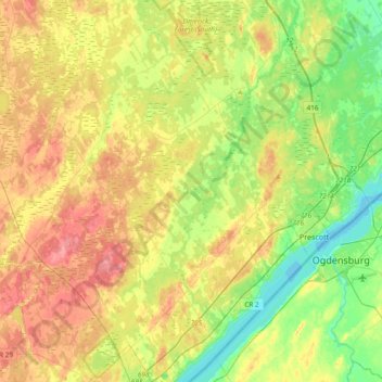
Name: Augusta topographic map, elevation, terrain.
Average elevation: 103 m
Minimum elevation: 72 m
Maximum elevation: 140 m
Make a donation
Gear up for your next adventure:
As an Amazon Associate, this site earns from qualifying purchases at no extra cost to you.
Other topographic maps
Click on a map to view its topography, its elevation and its terrain.
Shetland Island
Canada > Ontario > Leeds and Grenville Counties > Leeds and the Thousand Islands
Average elevation: 74 m
Quabbin
Canada > Ontario > Leeds and Grenville Counties > Leeds and the Thousand Islands
Average elevation: 97 m
Make a donation
Gear up for your next adventure:
As an Amazon Associate, this site earns from qualifying purchases at no extra cost to you.
Blakeys Point
Canada > Ontario > Leeds and Grenville Counties > Augusta > Blue Church
Average elevation: 82 m
Blue Mountain
Canada > Ontario > Leeds and Grenville Counties > Leeds and the Thousand Islands
Average elevation: 124 m
Make a donation
Gear up for your next adventure:
As an Amazon Associate, this site earns from qualifying purchases at no extra cost to you.
The Lake Fleet Islands
Canada > Ontario > Leeds and Grenville Counties > Leeds and the Thousand Islands
Average elevation: 108 m