
Thank you for supporting this site ❤️
Make a donation
Make a donation
Gear up for your next adventure:
As an Amazon Associate, this site earns from qualifying purchases at no extra cost to you.
Castelluccio topographic map
Click on the map to display elevation.
Thank you for supporting this site ❤️
Make a donation
Make a donation
Gear up for your next adventure:
As an Amazon Associate, this site earns from qualifying purchases at no extra cost to you.
About this map
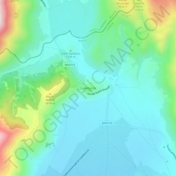
Name: Castelluccio topographic map, elevation, terrain.
Location: Castelluccio, Norcia, Perugia, Umbria, 06046, Italy (42.80878 13.18765 42.84878 13.22765)
Average elevation: 1,409 m
Minimum elevation: 1,281 m
Maximum elevation: 1,848 m
Thank you for supporting this site ❤️
Make a donation
Make a donation
Gear up for your next adventure:
As an Amazon Associate, this site earns from qualifying purchases at no extra cost to you.