
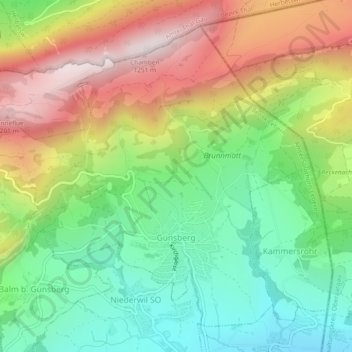
Günsberg topographic map
Interactive map
Click on the map to display elevation.
About this map
Name: Günsberg topographic map, elevation, terrain.
Average elevation: 785 m
Minimum elevation: 471 m
Maximum elevation: 1,216 m
Auf dem Hauptkamm der Jurakette verläuft der Jurahöhenweg.
Other topographic maps
Click on a map to view its topography, its elevation and its terrain.
Riedholz
Schweiz > Solothurn > Amtei Solothurn-Lebern
Riedholz, Bezirk Lebern, Amtei Solothurn-Lebern, Solothurn, Schweiz
Average elevation: 532 m
Bellach
Schweiz > Solothurn > Amtei Solothurn-Lebern
Bellach, Bezirk Lebern, Amtei Solothurn-Lebern, Solothurn, 4512, Schweiz
Average elevation: 457 m
Oberdorf (SO)
Schweiz > Solothurn > Amtei Solothurn-Lebern
Oberdorf (SO), Bezirk Lebern, Amtei Solothurn-Lebern, Solothurn, 4515, Schweiz
Average elevation: 805 m
Lommiswil
Schweiz > Solothurn > Amtei Solothurn-Lebern > Lommiswil
Lommiswil, Bezirk Lebern, Amtei Solothurn-Lebern, Solothurn, 4514, Schweiz
Average elevation: 749 m
Grenchen
Schweiz > Solothurn > Amtei Solothurn-Lebern
Grenchen, Bezirk Lebern, Amtei Solothurn-Lebern, Solothurn, 2540, Schweiz
Average elevation: 705 m
Balm bei Günsberg
Schweiz > Solothurn > Amtei Solothurn-Lebern
Balm bei Günsberg, Bezirk Lebern, Amtei Solothurn-Lebern, Solothurn, 4525, Schweiz
Average elevation: 834 m