
Dosuru topographic map
Interactive map
Click on the map to display elevation.
About this map
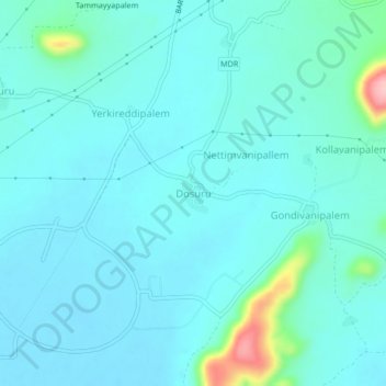
Name: Dosuru topographic map, elevation, terrain.
Location: Dosuru, Atchutapuram, Anakapalli, Andhra Pradesh, India (17.52730 83.01510 17.56730 83.05510)
Average elevation: 26 m
Minimum elevation: 3 m
Maximum elevation: 166 m
Other topographic maps
Click on a map to view its topography, its elevation and its terrain.
Duppituru
India > Andhra Pradesh > Atchutapuram
Duppituru, Atchutapuram, Anakapalli District, Andhra Pradesh, 531011, India
Average elevation: 22 m