
Irwin topographic map
Interactive map
Click on the map to display elevation.
About this map
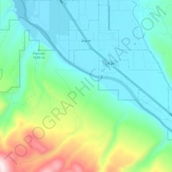
Name: Irwin topographic map, elevation, terrain.
Location: Irwin, Bonneville County, Idaho, États-Unis d'Amérique (43.35945 -111.30495 43.42216 -111.22549)
Average elevation: 1,790 m
Minimum elevation: 1,611 m
Maximum elevation: 2,363 m
Other topographic maps
Click on a map to view its topography, its elevation and its terrain.
Idaho Falls
États-Unis d'Amérique > Idaho > Bonneville County > Idaho Falls
Idaho Falls, Bonneville County, Idaho, 83403, États-Unis d'Amérique
Average elevation: 1,512 m