Geolocate

Edathode topographic map

Click on the map to display elevation.

About this map

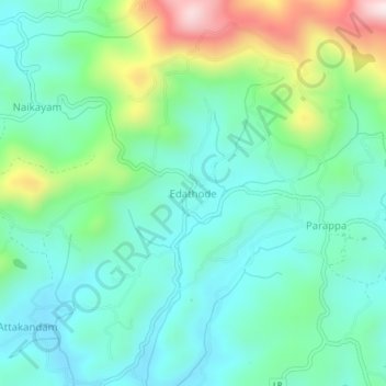
Name: Edathode topographic map, elevation, terrain.

Location: Edathode, Vellarikkundu, Kasaragod District, Kerala, India (12.35317 75.20992 12.39317 75.24992)

Average elevation: 195 m

Minimum elevation: 60 m

Maximum elevation: 577 m

Other topographic maps

Click on a map to view its topography, its elevation and its terrain.

Manadukam

India > Kerala > Vellarikkundu > Manadukkam > Vellakkallu Colony

Average elevation: 123 m

Vellarikundu

India > Kerala > Vellarikkundu > Kadumeni

Average elevation: 85 m

Gear up for your next adventure:

🔋Solar Chargers - Eco-friendly charging solutions for outdoor use
🎒Hiking Daypacks (20L) - Compact backpacks for day trips and technical mountain ascents
👖Packable Overtrousers - Quick-deploy rain protection for legs in sudden storms
🧺Ultralight Dry Bags - Organize and waterproof your gear inside your rucksack
🧦Merino Wool Hiking Socks - Moisture-wicking socks to prevent blisters during long mountain walks

As an Amazon Associate, this site earns from qualifying purchases at no extra cost to you.