
Ollauri topographic map
Interactive map
Click on the map to display elevation.
About this map
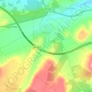
Name: Ollauri topographic map, elevation, terrain.
Location: Ollauri, La Rioja, 26220, Spanien (42.52728 -2.83801 42.54946 -2.81352)
Average elevation: 519 m
Minimum elevation: 466 m
Maximum elevation: 586 m
Ollauri liegt etwa 40 Kilometer südsüdwestlich von Vitoria-Gasteiz und etwa 35 Fahrtkilometer westnordwestlich von Logroño in einer Höhe von 505 m. Durch die Gemeinde führt die Autopista AP-68.
Other topographic maps
Click on a map to view its topography, its elevation and its terrain.
San Vicente de la Sonsierra
Spanien > La Rioja > San Vicente de la Sonsierra
San Vicente de la Sonsierra, La Rioja, Spanien
Average elevation: 586 m