
Make a donation
Gear up for your next adventure:
As an Amazon Associate, this site earns from qualifying purchases at no extra cost to you.
Tor topographic map
Click on the map to display elevation.
Make a donation
Gear up for your next adventure:
As an Amazon Associate, this site earns from qualifying purchases at no extra cost to you.
Tor
Tor está situado al fondo de un valle que se ensancha justo en el lugar donde se encuentra el pueblo. Está bajo una pequeña montaña conocida como el Roc de Sant Pere y enmarcada por las altas montañas como el Pico de Sanfonts (de 2.882,4 metros de altitud) que separan el valle de Vall Ferrera de los valles de Andorra.
Make a donation
Gear up for your next adventure:
As an Amazon Associate, this site earns from qualifying purchases at no extra cost to you.
About this map
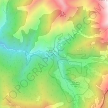
Name: Tor topographic map, elevation, terrain.
Location: Tor, Alins, Pallars Sobirá, Lérida, Cataluña, 25574, España (42.55054 1.37758 42.59054 1.41758)
Average elevation: 2,029 m
Minimum elevation: 1,503 m
Maximum elevation: 2,747 m
Make a donation
Gear up for your next adventure:
As an Amazon Associate, this site earns from qualifying purchases at no extra cost to you.