Geolocate

Silchar topographic map

Click on the map to display elevation.

About this map

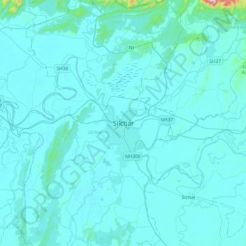
Name: Silchar topographic map, elevation, terrain.

Location: Silchar, Cachar, Assam, 788014, India (24.66959 92.63715 24.98959 92.95715)

Average elevation: 32 m

Minimum elevation: 9 m

Maximum elevation: 540 m

Gear up for your next adventure:

🧺Microfibre Travel Towels - Fast-drying and compact towels for wild swimming and camping
🚲Cycling GPS Computers - Track elevation and topographic routes on two wheels
🥾Trekking Poles - Poles to improve stability on uneven terrain
📢Survival Whistles - Essential safety gear for signaling for help in mountain fog
🔭Compact Hiking Binoculars - Lightweight optics for scouting terrain and spotting wildlife

As an Amazon Associate, this site earns from qualifying purchases at no extra cost to you.