
Key Biscayne topographic map
Interactive map
Click on the map to display elevation.
Key Biscayne
Key Biscayne lies south of Miami Beach and east of Miami. The village is connected to Miami via the Rickenbacker Causeway, originally built in 1947. Because of its low elevation and direct exposure to the Atlantic Ocean, it is usually among the first Miami areas to be evacuated before an oncoming hurricane.
About this map
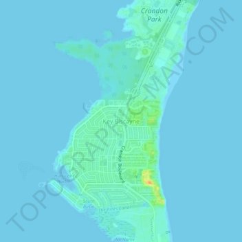
Name: Key Biscayne topographic map, elevation, terrain.
Average elevation: 3 m
Minimum elevation: -1 m
Maximum elevation: 30 m
Other topographic maps
Click on a map to view its topography, its elevation and its terrain.
Miami
United States > Florida > Miami-Dade County
Miami and its suburbs are located on a broad plain between the Everglades to the west and Biscayne Bay to the east, which extends from Lake Okeechobee southward to Florida Bay. The elevation of the area averages at around 6 ft (1.8 m) above sea level in most neighborhoods, especially near the coast. The…
Average elevation: 5 m
Miami
United States > Florida > Miami-Dade County
Miami is characterized by its unique topography, which features a broad coastal plain lying between the expansive Everglades to the west and the tranquil waters of Biscayne Bay to the east. The average elevation across the city is approximately 16 feet (5 meters) above sea level, with some areas dipping…
Average elevation: 5 m
Golden Glades
United States > Florida > Miami-Dade County > Hialeah > Golden Glades
Average elevation: 8 m
West Little River
United States > Florida > Miami-Dade County > Miami > West Little River
Average elevation: 7 m
Miami
United States > Florida > Miami-Dade County
Miami and its suburbs are located on a broad plain between the Everglades to the west and Biscayne Bay to the east, which extends from Lake Okeechobee southward to Florida Bay. The elevation of the area averages at around 6 ft (1.8 m) above sea level in most neighborhoods, especially near the coast. The…
Average elevation: 5 m
Miami
United States > Florida > Miami-Dade County
Miami and its suburbs are located on a broad plain between the Everglades to the west and Biscayne Bay to the east, which extends from Lake Okeechobee southward to Florida Bay. The elevation of the area averages at around 6 ft (1.8 m) above sea level in most neighborhoods, especially near the coast. The…
Average elevation: 5 m
Aventura
United States > Florida > Miami-Dade County
In addition to its sea-level elevation, coastal location and position just north of the Tropic of Cancer, the area owes its warm, humid climate to the Gulf Stream, which moderates climate year-round. A typical summer day does not see temperatures below 75 °F (24 °C). Temperatures in the high 80s to low 90s…
Average elevation: 7 m
Miami
United States > Florida > Miami-Dade County
Miami and its suburbs are located on a broad plain between the Everglades to the west and Biscayne Bay to the east, which extends from Lake Okeechobee southward to Florida Bay. The elevation of the area averages at around 6 ft (1.8 m) above sea level in most neighborhoods, especially near the coast. The…
Average elevation: 5 m
South Miami Heights
United States > Florida > Miami-Dade County > South Miami Heights
Average elevation: 6 m
Aventura
United States > Florida > Miami-Dade County > Aventura
In addition to its sea-level elevation, coastal location and position just north of the Tropic of Cancer, the area owes its warm, humid climate to the Gulf Stream, which moderates climate year-round. A typical summer day does not see temperatures below 75 °F (24 °C). Temperatures in the high 80s to low 90s…
Average elevation: 7 m
West Little River
United States > Florida > Miami-Dade County > West Little River
Average elevation: 7 m