
Neuenahrer Berg topographic map
Interactive map
Click on the map to display elevation.
About this map
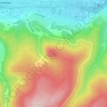
Name: Neuenahrer Berg topographic map, elevation, terrain.
Average elevation: 213 m
Minimum elevation: 85 m
Maximum elevation: 367 m
Other topographic maps
Click on a map to view its topography, its elevation and its terrain.
Ahrweiler
Deutschland > Rheinland-Pfalz > Landkreis Ahrweiler > Bad Neuenahr-Ahrweiler > Walporzheim
Ahrweiler, Walporzheim, Bad Neuenahr-Ahrweiler, Landkreis Ahrweiler, Rheinland-Pfalz, 53474, Deutschland
Average elevation: 283 m
Walporzheim
Deutschland > Rheinland-Pfalz > Landkreis Ahrweiler > Bad Neuenahr-Ahrweiler
Walporzheim, Bad Neuenahr-Ahrweiler, Landkreis Ahrweiler, Rheinland-Pfalz, Deutschland
Average elevation: 219 m
Ramersbach
Deutschland > Rheinland-Pfalz > Landkreis Ahrweiler > Bad Neuenahr-Ahrweiler
Ramersbach, Bad Neuenahr-Ahrweiler, Landkreis Ahrweiler, Rheinland-Pfalz, Deutschland
Average elevation: 414 m
Lohrsdorf
Deutschland > Rheinland-Pfalz > Landkreis Ahrweiler > Bad Neuenahr-Ahrweiler
Lohrsdorf, Bad Neuenahr-Ahrweiler, Landkreis Ahrweiler, Rheinland-Pfalz, Deutschland
Average elevation: 141 m
Marienthal
Deutschland > Rheinland-Pfalz > Landkreis Ahrweiler > Bad Neuenahr-Ahrweiler > Marienthal
Marienthal, Bad Neuenahr-Ahrweiler, Landkreis Ahrweiler, Rheinland-Pfalz, Deutschland
Average elevation: 232 m
Neuenahr
Deutschland > Rheinland-Pfalz > Landkreis Ahrweiler > Bad Neuenahr-Ahrweiler
Neuenahr, Bad Neuenahr-Ahrweiler, Landkreis Ahrweiler, Rheinland-Pfalz, Deutschland
Average elevation: 242 m