
Thank you for supporting this site ❤️
Make a donation
Make a donation
Gear up for your next adventure:
As an Amazon Associate, this site earns from qualifying purchases at no extra cost to you.
Littleton topographic map
Click on the map to display elevation.
Thank you for supporting this site ❤️
Make a donation
Make a donation
Gear up for your next adventure:
As an Amazon Associate, this site earns from qualifying purchases at no extra cost to you.
About this map
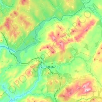
Name: Littleton topographic map, elevation, terrain.
Location: Littleton, Grafton County, New Hampshire, United States (44.27124 -71.98454 44.40667 -71.69669)
Average elevation: 360 m
Minimum elevation: 176 m
Maximum elevation: 730 m
Thank you for supporting this site ❤️
Make a donation
Make a donation
Gear up for your next adventure:
As an Amazon Associate, this site earns from qualifying purchases at no extra cost to you.
Other topographic maps
Click on a map to view its topography, its elevation and its terrain.
North Littleton
United States > New Hampshire > Grafton County > Littleton > North Littleton
Average elevation: 333 m