Geolocate

Sheering topographic map

Click on the map to display elevation.

About this map

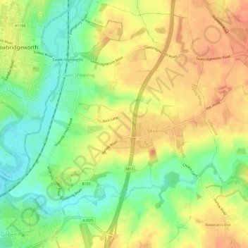
Name: Sheering topographic map, elevation, terrain.

Location: Sheering, Epping Forest, Essex, England, United Kingdom (51.78622 0.14584 51.82215 0.19638)

Average elevation: 66 m

Minimum elevation: 42 m

Maximum elevation: 85 m

Essex trails, hiking, mountain biking, running and outdoor activities

Gear up for your next adventure:

🧤Waterproof Overmitts - Extreme weather protection for hikers and mountaineers
🧷Tenacious Repair Tape - Instant fix for torn tents, jackets, or dry bags
🔦Head Torches - Hands-free lighting for hiking and camping
Lightweight Solo Tents - Backpacking tents designed for wild camping in the UK highlands
🎒Hiking Daypacks (20L) - Compact backpacks for day trips and technical mountain ascents

As an Amazon Associate, this site earns from qualifying purchases at no extra cost to you.