
Ellange topographic map
Interactive map
Click on the map to display elevation.
About this map
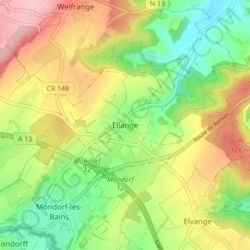
Name: Ellange topographic map, elevation, terrain.
Location: Ellange, Mondorf-les-Bains, Canton Remich, 5690, Luxembourg (49.50101 6.27771 49.54101 6.31771)
Average elevation: 246 m
Minimum elevation: 165 m
Maximum elevation: 346 m
Other topographic maps
Click on a map to view its topography, its elevation and its terrain.
Ellange Gare
Luxembourg > Canton Remich > Ellange > Ellange Gare
Ellange Gare, Ellange, Mondorf-les-Bains, Canton Remich, 5691, Luxembourg
Average elevation: 242 m