
Make a donation
Gear up for your next adventure:
As an Amazon Associate, this site earns from qualifying purchases at no extra cost to you.
Nilphamari topographic map
Click on the map to display elevation.
Make a donation
Gear up for your next adventure:
As an Amazon Associate, this site earns from qualifying purchases at no extra cost to you.
About this map
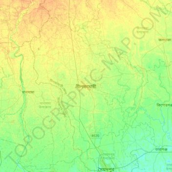
Name: Nilphamari topographic map, elevation, terrain.
Average elevation: 46 m
Minimum elevation: 34 m
Maximum elevation: 58 m
Make a donation
Gear up for your next adventure:
As an Amazon Associate, this site earns from qualifying purchases at no extra cost to you.
Other topographic maps
Click on a map to view its topography, its elevation and its terrain.
Nilphamari Paurashava
Bangladesh > Rangpur Division > Nilphamari Sadar Upazila
The city is situated on the Barind Tract, a slightly elevated Pleistocene terrace, with an average elevation of 45 metres (148 ft) above sea level. The terrain is generally flat, sloping gently from north to south. The highest point in the city is approximately 47 metres (154 ft), while the lowest is around 44…
Average elevation: 47 m