
Heinsberg topographic map
Interactive map
Click on the map to display elevation.
About this map
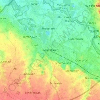
Name: Heinsberg topographic map, elevation, terrain.
Average elevation: 49 m
Minimum elevation: 28 m
Maximum elevation: 77 m
Das Amt Heinsberg war gerichtlich in sechs Bezirke eingeteilt, sogenannte Dingstühle oder Schöffengerichte. Für sie war das Stadtgericht Heinsberg die nächsthöhere Instanz.