
Make a donation
Gear up for your next adventure:
As an Amazon Associate, this site earns from qualifying purchases at no extra cost to you.
Mutilva topographic map
Click on the map to display elevation.
Make a donation
Gear up for your next adventure:
As an Amazon Associate, this site earns from qualifying purchases at no extra cost to you.
Mutilva
La localidad se encuentra situada en la parte más occidental del valle de Aranguren el cual a su vez se encuentra ubicado en la parte central de la Comunidad Foral de Navarra dentro de la Cuenca de Pamplona. La altitud del núcleo de población es de 442 m s. n. m..
Make a donation
Gear up for your next adventure:
As an Amazon Associate, this site earns from qualifying purchases at no extra cost to you.
About this map
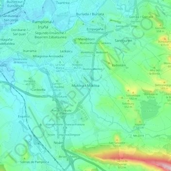
Name: Mutilva topographic map, elevation, terrain.
Location: Mutilva, Aranguren, Área Metropolitana, Navarra, 31016, España (42.74947 -1.65687 42.82947 -1.57687)
Average elevation: 470 m
Minimum elevation: 408 m
Maximum elevation: 734 m
Make a donation
Gear up for your next adventure:
As an Amazon Associate, this site earns from qualifying purchases at no extra cost to you.