
Mayor Island / Tuhua topographic map
Interactive map
Click on the map to display elevation.
About this map
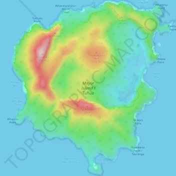
Name: Mayor Island / Tuhua topographic map, elevation, terrain.
Location: Mayor Island / Tuhua, Tauranga, Bay of Plenty, Neuseeland (-37.31045 176.23128 -37.26758 176.28073)
Average elevation: 71 m
Minimum elevation: 0 m
Maximum elevation: 344 m