
Altstadt topographic map
Interactive map
Click on the map to display elevation.
About this map
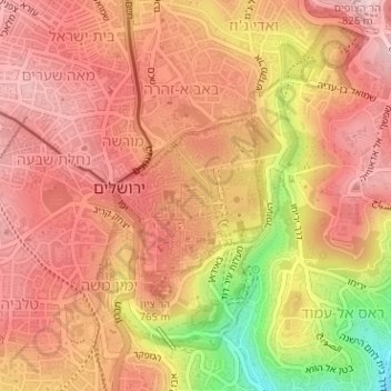
Name: Altstadt topographic map, elevation, terrain.
Location: Altstadt, Jerusalem, Bezirk Jerusalem, Israel (31.77281 35.22570 31.78374 35.23756)
Average elevation: 749 m
Minimum elevation: 583 m
Maximum elevation: 825 m
Other topographic maps
Click on a map to view its topography, its elevation and its terrain.
Jerusalem
Israel > Bezirk Jerusalem > Jerusalem
Jerusalem, Bezirk Jerusalem, Israel
Average elevation: 661 m