
Make a donation
Gear up for your next adventure:
As an Amazon Associate, this site earns from qualifying purchases at no extra cost to you.
Grand-Rosière-Hottomont topographic map
Click on the map to display elevation.
Make a donation
Gear up for your next adventure:
As an Amazon Associate, this site earns from qualifying purchases at no extra cost to you.
About this map
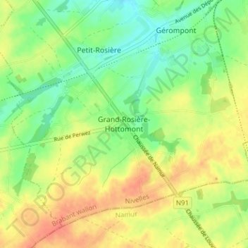
Name: Grand-Rosière-Hottomont topographic map, elevation, terrain.
Average elevation: 142 m
Minimum elevation: 119 m
Maximum elevation: 165 m
Make a donation
Gear up for your next adventure:
As an Amazon Associate, this site earns from qualifying purchases at no extra cost to you.
Other topographic maps
Click on a map to view its topography, its elevation and its terrain.
Louvain-la-Neuve
Belgique > Brabant wallon > Nivelles > Ottignies-Louvain-la-Neuve
Average elevation: 123 m
Make a donation
Gear up for your next adventure:
As an Amazon Associate, this site earns from qualifying purchases at no extra cost to you.
Make a donation
Gear up for your next adventure:
As an Amazon Associate, this site earns from qualifying purchases at no extra cost to you.
Make a donation
Gear up for your next adventure:
As an Amazon Associate, this site earns from qualifying purchases at no extra cost to you.
Nivelles
Belgique > Brabant wallon > Nivelles
Sa latitude est de 50° 35' N, pour une longitude de 4° 19' E et une altitude de 65 à 167 mètres. Une superficie de 6 060 hectares lui confère une densité de 429 habitants au kilomètre carré. Elle est située en aval par rapport aux campagnes environnantes.
Average elevation: 132 m
Perwez
Belgique > Brabant wallon > Nivelles
La commune de Perwez se situe à l'est du Brabant wallon et partage sa limite méridionale avec la Province de Namur. Cette frontière suit en grande partie l'ancienne Chaussée romaine qui reliait Bavay à Cologne. Au cœur de la région hesbignonne limoneuse, la commune est arrosée par quelques cours d'eau…
Average elevation: 146 m
Make a donation
Gear up for your next adventure:
As an Amazon Associate, this site earns from qualifying purchases at no extra cost to you.
Make a donation
Gear up for your next adventure:
As an Amazon Associate, this site earns from qualifying purchases at no extra cost to you.
Make a donation
Gear up for your next adventure:
As an Amazon Associate, this site earns from qualifying purchases at no extra cost to you.
Make a donation
Gear up for your next adventure:
As an Amazon Associate, this site earns from qualifying purchases at no extra cost to you.
Ophain-Bois-Seigneur-Isaac
Belgique > Brabant wallon > Nivelles > Braine-l'Alleud
Average elevation: 126 m
Make a donation
Gear up for your next adventure:
As an Amazon Associate, this site earns from qualifying purchases at no extra cost to you.
Céroux-Mousty
Belgique > Brabant wallon > Nivelles > Ottignies-Louvain-la-Neuve
Average elevation: 102 m
Make a donation
Gear up for your next adventure:
As an Amazon Associate, this site earns from qualifying purchases at no extra cost to you.
Make a donation
Gear up for your next adventure:
As an Amazon Associate, this site earns from qualifying purchases at no extra cost to you.
Château des Comtes de Hornes
Belgique > Brabant wallon > Nivelles > Braine-le-Château
Average elevation: 86 m
Make a donation
Gear up for your next adventure:
As an Amazon Associate, this site earns from qualifying purchases at no extra cost to you.
Bois de Lauzelle
Belgique > Brabant wallon > Nivelles > Ottignies-Louvain-la-Neuve
Average elevation: 108 m
Make a donation
Gear up for your next adventure:
As an Amazon Associate, this site earns from qualifying purchases at no extra cost to you.
Make a donation
Gear up for your next adventure:
As an Amazon Associate, this site earns from qualifying purchases at no extra cost to you.
Make a donation
Gear up for your next adventure:
As an Amazon Associate, this site earns from qualifying purchases at no extra cost to you.
Make a donation
Gear up for your next adventure:
As an Amazon Associate, this site earns from qualifying purchases at no extra cost to you.
Make a donation
Gear up for your next adventure:
As an Amazon Associate, this site earns from qualifying purchases at no extra cost to you.
Make a donation
Gear up for your next adventure:
As an Amazon Associate, this site earns from qualifying purchases at no extra cost to you.
Make a donation
Gear up for your next adventure:
As an Amazon Associate, this site earns from qualifying purchases at no extra cost to you.
Make a donation
Gear up for your next adventure:
As an Amazon Associate, this site earns from qualifying purchases at no extra cost to you.
Make a donation
Gear up for your next adventure:
As an Amazon Associate, this site earns from qualifying purchases at no extra cost to you.
Make a donation
Gear up for your next adventure:
As an Amazon Associate, this site earns from qualifying purchases at no extra cost to you.
Make a donation
Gear up for your next adventure:
As an Amazon Associate, this site earns from qualifying purchases at no extra cost to you.
Piroi
Belgique > Brabant wallon > Nivelles > Braine-l'Alleud > Ophain-Bois-Seigneur-Isaac
Average elevation: 117 m
Make a donation
Gear up for your next adventure:
As an Amazon Associate, this site earns from qualifying purchases at no extra cost to you.
Les Culots
Belgique > Brabant wallon > Nivelles > Braine-l'Alleud > Ophain-Bois-Seigneur-Isaac
Average elevation: 126 m
Make a donation
Gear up for your next adventure:
As an Amazon Associate, this site earns from qualifying purchases at no extra cost to you.
Make a donation
Gear up for your next adventure:
As an Amazon Associate, this site earns from qualifying purchases at no extra cost to you.