Geolocate

Mon Repos topographic map

Click on the map to display elevation.

About this map

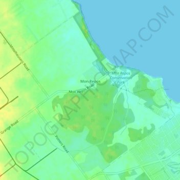
Name: Mon Repos topographic map, elevation, terrain.

Location: Mon Repos, Bundaberg Region, Queensland, Australia (-24.82337 152.42344 -24.78668 152.45764)

Average elevation: 9 m

Minimum elevation: 0 m

Maximum elevation: 24 m

Gear up for your next adventure:

👟Men's Trail Running Shoes - Lightweight grip for fast movement over topographic contours
🧦Merino Wool Hiking Socks - Moisture-wicking socks to prevent blisters during long mountain walks
📢Survival Whistles - Essential safety gear for signaling for help in mountain fog
📸Action Camera Chest Mounts - Record your ascent following topographic paths hands-free
🧢Hiking Hats - Sun and weather protection for outdoor walks

As an Amazon Associate, this site earns from qualifying purchases at no extra cost to you.